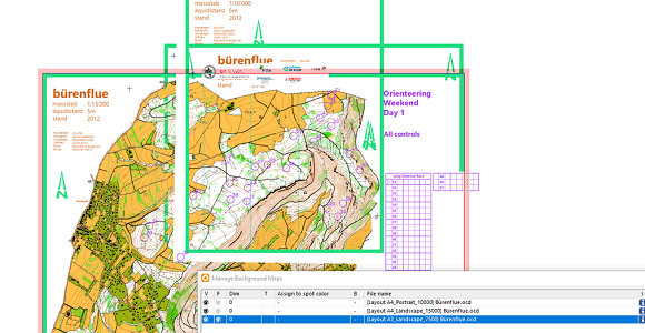
For a long distance orienteering race, the following courses and classes are offered.
– Long Course, Class WE, Scale 15’000 – Medium Course, Class W18, Scale 10’000 – Medium Course, Class M60, Scale 7’500 – Short Course, Class M80, Scale 7’500
Thanks to the Canvases function, all courses and/or classes can be automatically exported as PDF from a single course setting project in the specified scale and layout. Especially for larger events, this reduces the time required and potential sources of error.
World Orienteering Day(WOD) is a project of the International Orienteering Federation to increase the visibility and accessibility of orienteering worldwide.
This year, between the dates May 11th and May 17th 2022, any orienteering activity held can be registered as a World Orienteering Day event.
OCAD is one of World Orienteering Day’s partners and we offer a free OCAD Starter License for those who register for a WOD event. The licenses will run until August 2022.
OCAD Starter does not only include the Course Setting Module, but also the New Map Wizard, with which you can create an orienteering map anywhere in the world with just a few clicks.
Three new orienteering symbol sets are available in the latest OCAD Update:
Updated ISSprOM 2019-2
Minor Update to ISOM 2017-2
New ISMTBOM 2022 released
Updated ISSprOM 2019-2
The International Specification for Sprint Orienteering Maps (ISSprOM 2019-2) has been updated and is valid from 15th January 2022.
The sprint orienteering symbol sets in OCAD have been updated to meet the new specifications and are included in the latest OCAD Update.
The biggest changes concern the representation of complex urban structures with multiple levels, such as tunnels, bridges or passages. In addition, impassable vegetation and impassable hedges are again displayed with dark green color.
In OCAD, existing sprint orienteering maps can be updated to the new standards in two different ways.
If your map contain the original ISSprOM 2019 symbol set, use the Update Symbol Setfunction.
To update an old sprint orienteering symbol set, use the function Symbol Set Conversion.
Minor Update to ISOM 2017-2
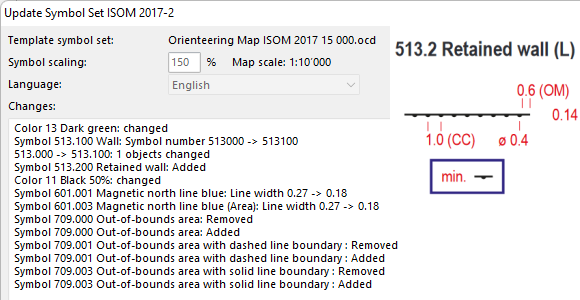
There was a minor update to The International Specification for Orienteering Maps (ISOM 2017-2) to make the parameters of some symbols consistent (e.g. 709 Out of bounds area). Also, a new symbol 513.2 Retained wall has been added to allow mapping of walls visible from only one side.
In OCAD, existing forest orienteering maps can be updated to the new standards in two different ways.
If your map contain the original ISOM 2017-1 or ISOM 2017-2 symbol set, use the Update Symbol Setfunction.
To update an old forest orienteering symbol set, use the function Symbol Set Conversion.
New ISMTBOM 2022 released
The International Specification for Mountain Bike Orienteering Maps (ISMTBOM2022) has been released and is valid from January 2022.
The mountain bike orienteering symbol sets in OCAD have been updated to meet the new specifications and are included in the latest OCAD Update.
Compared to the Final Draft from last October, there were only a few minor changes, such as additional symbols for narrow rides or linear traces through the terrain.
In OCAD, existing mountain bike orienteering maps can be easily updated to the new standards using the Symbol Set Conversion function.
Let’s take a look back at the three most important developments of the past year. Did you get them all?
#01: Sketch Layer
The Sketch Layer and it’s tools are designed for orienteering map field work with a tablet computer and a pen. The main approach is to make field work drawing as ergonomic as possible.
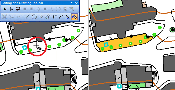
Thanks to the Fill Bounded Area mode you can draw your map even more efficiently. This function fills empty areas that are bounded by various objects from line or area symbols.
#03: Improved Live Preview
The Live Preview of objects makes their dimension visible already during drawing. Live preview is no longer limited to line objects, but is now also available for point objects.
In addition, a so-called Legibility Halo can be displayed for point objects. The distance of this legibility halo is based on the IOF specifications for orienteering maps and supports the cartographer to draw objects with enough distance to each other.
These were the biggest milestones last year, but stay tuned: We have great innovations in the pipeline this year as well!
Thanks to the live preview of objects, their dimension is already visible during drawing.
Since the latest OCAD Update 2020.5.12, the live preview is no more only limited to line objects, but is also available for point objects.
In addition, a so-called legibility halo can be displayed for point objects. The distance of this legibility halo is based on the IOF specifications for orienteering maps and supports the cartographer to draw objects with enough distance to each other.