Monthly Archives: August 2016

Specialization Course: Reviving Thematic Cartography into Digital

The University IUAV of Venice is organising an international intensive post-graduate specialisation course Reviving Thematic Cartography into Digital, Venice, Italy, 14-26 November 2016.

The course is supported by the ICA Commission Cartographic Heritage into the Digital and offers a top-edge dense and focused package of knowledge and implementation skills in Thematic Cartography. At the end of the Course the participants should be able to make decisions and construct their own project getting familiar with relevant professional software like OCAD 12 ThematicMapper (a free license is offered during the course).

Read more…
(The application dealine is 15 September 2016)

Blend Modes for PDF Export – Print your Maps with More Transparency

The current OCAD 12 Service Update contains a very interesting new feature for map printing.

The blend mode was developed to get better transparent colors on the digital CMYK printed training and competition maps for Junior World Orienteering Championships 2016 and Swiss O Week 2016.

The blend mode controls how the underlying color of an object interacts with the blend color of the overlaying object.

The new blend mode settings affect only the map export to a pdf file.  OCAD supports the blend modes Darken und Multiply.

In Color dialog click the Blend mode button.

Set the Darken mode for the color Purple, Green over brown and Brown.

No blend mode effect in OCAD

The effect in not visible in OCAD!

But it is visible when opening the exported pdf file in Adobe Acrobat Reader.

Capture

Exported pdf in Adobe Acrobat Reader

  • Purple control circle is transparent, underlying objects with color blue, green and brown are visible
  • Green tree is transparent, underlying contour line is visible
  • Brown contour lines are transparent, underying green area is visible

More about the Blend Mode in our Wiki.

OCAD Presentations at the International Conference on Orienteering Mapping an the Open Technology Meeting of the IOF IT Commission

We are pleased to draw your attention to two OCAD presentations at the open meetings embedded into the World Orienteering Championships 2016  Strömstad, Sweden, 20-28 August.

The 17th International Conference on Orienteering Mapping will surely be a highlight for those of us who love maps. You can look forward to interesting presentations and discussions on topics such as generalisation, the application of LIDAR data, surveying techniques and software for orienteering mapping. Read the invitation here.  and the Programme here (15:40 – 16:00 OCAD 12 – What’s new).
When: Friday 26 August August, 12.00-17.00
Where: Event Centre (Strömstad Gymnasium)

Finally, the IOF IT Commission will organise an open technology meeting. The meeting will be a gathering of technology savvy orienteers for presentations and discussions about relevant technology – timekeeping, GPS, analysis, hardware, software etc. Don’t miss this chance to learn about the technology at the forefront of the development of orienteering! More information here. Check out the Schedule (#7: Use of OCAD Beyond Mapping: Arena Production, Punching and Course Setting).
When: Friday 26 August August, 18.00-20.00 
Where: Event Centre (Strömstad Gymnasium)

Shape Import in OCAD 12 Orienteering Edition

The newest OCAD 12 Orienteering Service Update 12.1.2  contains a new function to import geodata in Shape file format. Up to now this function was only available OCAD Professional and Mapping Solution.

Geodata are more and more freely accessible from government as Open Data. So use this geodata and import them in OCAD before starting drawing.

Example of geodata import (streets) from swisstopo :

File -> Import and choose the shp file. The Import Shape File appears.

ShapeImportDialog

After the import you have to assign the imported objects to existing symbols. So import also the classification from Shape file.
Chose Use layer information from field option and click on the View table button.

In the View Table dialog you can see all database fields with the values.

ShapeImportDialogViewTable

The classification (2_Klass, 3_Klass, 4_Klass,….) is in the OBJECTVAL field. Close this dialog and choose the OBJECTVAL field.

Click OK to import the data.

All imported objects are unsymbolized. Select one line object. The layer information 4_Klass for this object is visible on the left side of the status bar.

ShapeImportUnsymbolizedObjects

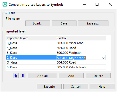
Assign these objects to symbols using the Convert Imported Layers to Symbols in the Map menu.

Click the Add all button to add all layers in the table. On the right side choose the corresponding symbols.

ShapeImportConvertLayer

Click Execute to symbolize the objects.

ShapeImportSymbolizedObjects