An extent is an area in OCAD that you define and save, which you can use for various purposes, such as printing, exporting, or creating a layout.
The latest OCAD Update brought improvements to reuse extents.
How to create an extent?
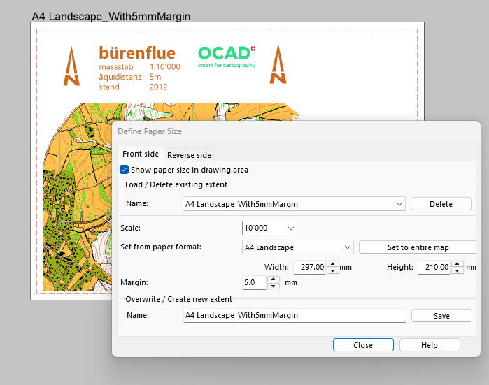
Use the Define Paper Size function to create and save a new extent. This can be a standard paper format like A4 or any custom format.
The extent will be shown in the drawing area and the area outside will be grayed out. This is helpful, for example, when you’re creating a layout for a map.
How to use an extent for exporting and printing
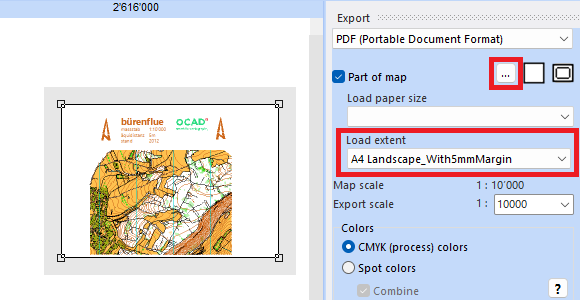
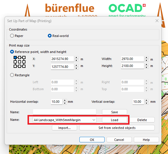
If you have saved an extent, it is also available both in the export dialog (Menu File > Export > Load extent) and in the print dialog (Menu File > Print > Part of map > Set Up…). In the latter dialog it is also possible to save and delete extents.
Improvements since the latest OCAD Update
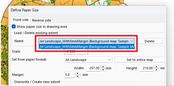
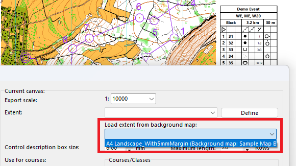
Since the latest OCAD Update, also extents from background maps can be loaded in the Define Paper Size and Canvas function.
This can be useful, for example, for course setting projects when you use the Canvas function and load already defined extents from your layouts files.
Sometimes you may want to hide certain parts of the map to make more room for logos, control descriptions, or layout elements.
What options are available in OCAD?
#01 Option: White background Symbol In course setting projects, you can use the White background symbol (760.000) as a quick solution. Select the White background symbol in the symbol box and cover parts of the map with white color. However, make sure that you do not cover any course objects (controls, control numbers, connection lines, …), as the withe color that is used in symbol 760 will cover course objects.
#02 Option: Layout Objects Open the Layout menu (Layout>Edit Layout Objects) and add a new white area object. Make sure the white area objects are at the bottom of the object list, if there are other layout elements in the list to not cover them.
#03 Option: Map Objects Define a new white color (Map>Colors>Add) and move it to desired position in the color table (e.g. to the very top). In a second step, create a new area symbol (Symbol>New>Area Symbol) where you use the newly created color as Fill color.
#04 Option: Cut Away Parts of the Map Alternatively, you can cut away parts of the map instead of just cover them. If so, make sure you are working with a copy and not the original map.
Recommendations
It is generally up to you whether you use the options listed above directly in the map file, in the course setting file, or in a layout file.
In the Course Setting module of OCAD, a Map Flip or Map Exchange can be inserted into a course.
This opens up new advantages and possibilities when setting courses:
○ A course can be printed in A4 format instead of A3. (Example) ○ An (interesting) area can be used several times. (Example) ○ The course setter can surprise the runners with a route choice after the Map Flip/ Map Exchange.
Difference between Map Flip and Map Exchange
A Map Flip means, that the runner needs to turn the map over and continue the second part of the course on the backside of the map.
Course with Map Flip. The Map Flip symbol appears in the control description.
A Map Exchange means, that the runner needs to take a new map and continue the course on the new map.
Course with two Map Exchanges. The Map Exchange appears in the control description. There can be more than one Map Exchange during a course.
Both, Map Flip or Map Exchange, can be placed after a control or after a Marked Route.
In contrast to the Map Flip, where the runner can turn the map independently, the Map Exchange requires effort on the part of the organizer (e.g. map boxes, helpers, …). However, at a Map Exchange the runner can not read the course ahead on the backside, the paper format can be changed and the runners get a ‘fresh, undamaged’ map.
Export PDFs for Printing
If a Map Flip is added to a course and a PDF is exported, a single PDF file with two pages will be exported for double-sided printing. The front and back can contain the same or two different map extracts.
Single PDF file with two pages for double-Sided printing.
A Map Exchange creates two single-page PDFs. The paper format of the two PDFs can be different.
Two separate PDF files with one page each.
We recommended not printing courses with Map Flips and Map Exchanges directly from OCAD. Instead use the Canvas function to export PDFs and print them from Adobe Acrobat Reader. This is especially useful for larger course setting projects or if you want to assign different map extracts to the sub-courses.
If there is a course with a Map Flip or Map Exchange, you can see that this course is split up into sub-courses (e.g. Map flip #1 and Map flip #2) in the Canvas dialog. You can add a different map extract for each sub-course if needed.
Note: The term ‘backside’ has been changed to ‘reverse side’.
With the latest OCAD Update the option Use backside for PDF export has been added. This option allows you to export a PDF with two pages for double-sided printing.
In the Define Paper Size function of the Layout menu, there is now a tab to define a frontside and a backside for an extent. If the option Use backside for PDF export is activated in the Backside tab, an extent for the backside can be defined as well. This must have the same paper size (e.g. A4) as the frontside, but can cover a different a map extent.
Exporting double-sided PDF
In the Export dialog, you can then load the double-sided extent to export a PDF with two pages for double-sided printing.
In the Canvas function, you can choose between Frontside, Backside or double-sided if there is an extent with a backside defined. -> Example
Applications for double-sided printing
You can print the course title, start number, relay variant, … on the backside. -> Example
You can add a Map Flip to an orienteering course. This means that the runner has to flip the map to continue the course on the backside. This opens up new advantages and possibilities when setting courses: ○ A course can be printed in A4 format instead of A3. -> Example
○ An (interesting) area can be used several times. -> Example
How to print a double sided PDF?
Open and print the double-sided PDF in Adobe Reader, where you have the possibility to set the option Print on both sides of paper.
There are various ways to create a layout for a map in OCAD. Creating an appealing map layout quickly becomes a challenge and requires in-depth knowledge of OCAD.
We have therefore compiled information and tips on the subject of creating map layouts in our OCAD Wiki.