In OCAD, you can create objects with pair of coordinates. Copy coordinates e.g. from Google Maps to clipboard. When you press Paste in the OCAD window (Ctrl + V or in the Menu Object> Paste), a dialogue window appears.
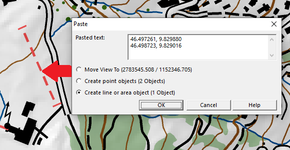
Now you have three options:
You can move the view to this coordinates, create point objects at the coordinates or create line or area objects (only available if more than one pair of coordinates exists).
To use this function properly, a coordinate system has to be defined and the pasted coordinates need to fit to this coordinate system.
Link to HowTo-Video
More information on our Wiki
Supported formats so far:
– Google: 47.4563036,7.6405326
– Google: -24.8512749,-59.8029067
– OpenStreetMap: 47.45295/7.64673
– OpenStreetMap: -37.762/-62.183
– OpenStreetMap: 46.3103041, 4.8142705
– geo.admin.ch: 615’582.01, 256’284.55
– geo.admin.ch: 47.45648, 7.64039
– geo.admin.ch: 47°27′23.313″N 7°38′25.401″E