Tag Archives: Smarte Bearbeitungs-Tools

OCAD Sketch Layer

With the latest update we launched the OCAD Sketch Layer as a Beta version.

The new Sketch Layer and it’s tools are designed for orienteering map field work with a tablet computer and a pen.

OCAD Sketch Layer

Mapping with a tablet in the terrain has some compelling advantages like real-time GPS positioning and the possibility to switch between different background maps. However, the drawing and editing tools were not yet designed for use with a tablet and pen.

This was the trigger for this latest development: The OCAD Sketch Layer makes drawing on the tablet very ergonomic. Even more: Numerous colors and different line widths are available and with the eraser tool you can very easily delete parts of the sketch without having to select the features before.

Learn more about it in our Video on YouTube and in the OCAD Wiki

… and give it a try!
The Sketch Layer can be used with the latest Update of the OCAD editions Mapping Solution, Orienteering and Starter and in our free Trial versions of these editions.

We look forward to your feedback and suggestions!

Note: The tools and functions around the OCAD Sketch Layer are a Beta version. We recommend to make regular backups.

Timesavers in OCAD

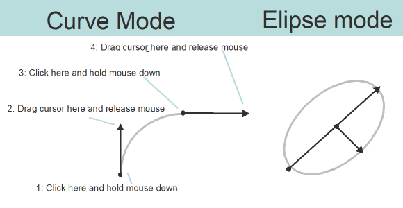
In the last OCAD Blog the different drawing modes were introduced. As you have probably already experienced, drawing objects requires practice and takes time. It becomes tedious if you have to draw an object apparently twice, for example a border line with a fill area.

Fortunately, you can duplicate objects so that you don’t have to draw them twice.

To only duplicate an object, you can use the Duplicate or Move and Duplicate function. Or simply select an object in the drawing window, press CTRL+C and CTRL+V.

Now let’s take the Fill or Make Border or Duplicate Identically function. As its name indicates and as you can see in the picture below, you can fill areas, make borders or duplicate object identically. Select e.g. a water area and add a border line with just one click.

To duplicate (or only move) a line, line text or area object parallel with a certain distance, there’ s the Move/Duplicate Parallel by Specified Distance function.

Last but not least, there’s the Move Parallel function, with which you also have the possibility to duplicate objects by holding the CTRL+SHIFT keys.

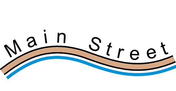
In the example below we have only drawn the main street and added the labelling and the watercourse with the function Move Parallel. Besides the time saving, the absolutely parallel course of the objects should be mentioned.

Drawing modes in OCAD

To draw an object in OCAD, you need to select a drawing mode. Since the last Service Update, there is a tutorial file to familiarize beginners with the different drawing modes. But also advanced OCAD users will make one or the other discovery.

Therefore it is definitely worth a look!

The Drawing modes.ocd file can be opened in the folder OCAD menu File > Open Sample Maps.

Update Sprint Maps to ISSprOM 2019

On 1 January 2020 the new ISSprOM 2019 came into force, which defines the mapping standard for sprint orienteering maps.

Sprint maps, which were still drawn according to the old ISSOM 2007 standard, can be easily updated to ISSprOM 2019 using the function Symbol Set Conversion.

We prepared a short Video on YouTube, which explains how to convert your maps to the new standards.