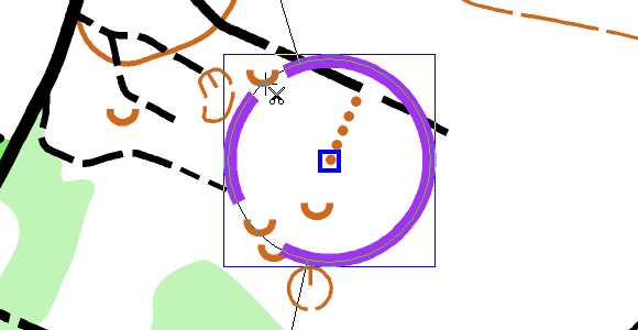
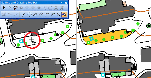
Often, an orienteering competition starts with a marked route to the start point. Nowadays, you also mark the Map Issue Point. It’s the place where you get the map and it is marked with a horizontal line.
There is a symbol 702.000 for the Map Issue Point. If your course setting project contains just one start, that’s all right. However, it get’s annoying if there are more than one start and Map Issue Points, as all of them will be show in Course Preview.
Course setting project with two courses. Each course has its own start.Course Preview of one of the courses. Both Map Issue Points are displayed, as Symbol 702.000 was used.
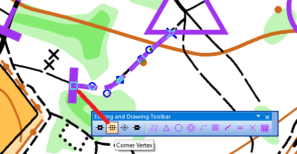
It’s better to include the Map Issue Point into the marked route, that leads to the start point. For that, you need to insert a Corner Vertex into the marked route.
Insert a Corner Vertex into the marked route to mark the Map Issue Point……as now only one Map Issue Point will be displayed in Course Preview.
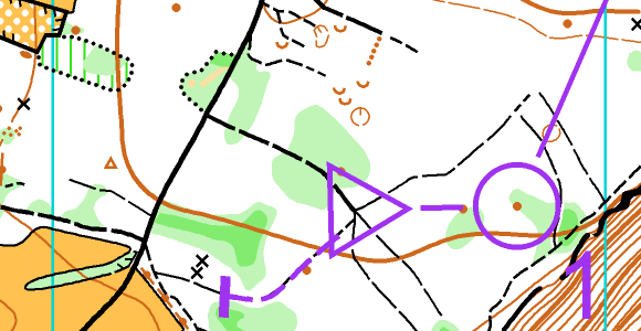
Now, the Map Issue Points will only be displayed if the corresponding course is previewed/ exported.
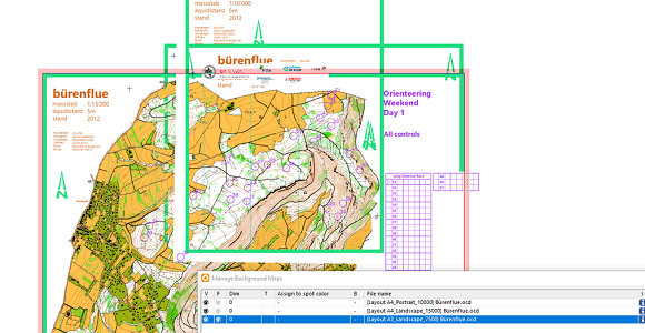
For a long distance orienteering race, the following courses and classes are offered.
– Long Course, Class WE, Scale 15’000 – Medium Course, Class W18, Scale 10’000 – Medium Course, Class M60, Scale 7’500 – Short Course, Class M80, Scale 7’500
Thanks to the Canvases function, all courses and/or classes can be automatically exported as PDF from a single course setting project in the specified scale and layout. Especially for larger events, this reduces the time required and potential sources of error.
Let’s take a look back at the three most important developments of the past year. Did you get them all?
#01: Sketch Layer
The Sketch Layer and it’s tools are designed for orienteering map field work with a tablet computer and a pen. The main approach is to make field work drawing as ergonomic as possible.
Thanks to the Fill Bounded Area mode you can draw your map even more efficiently. This function fills empty areas that are bounded by various objects from line or area symbols.
#03: Improved Live Preview
The Live Preview of objects makes their dimension visible already during drawing. Live preview is no longer limited to line objects, but is now also available for point objects.
In addition, a so-called Legibility Halo can be displayed for point objects. The distance of this legibility halo is based on the IOF specifications for orienteering maps and supports the cartographer to draw objects with enough distance to each other.
These were the biggest milestones last year, but stay tuned: We have great innovations in the pipeline this year as well!
Take a chance and with a little luck get an OCAD license!
OCAD is sponsor of the following two contests:
Course of the Year by worldofo.com
There will be a voting process among the readers of the popular website World of O in order to name The course of the year 2021 in each category (Sprint, Middle and Long).
OCAD is one of the sponsors of this inspiring survey and you have the chance to win a 3-Year OCAD Orienteering license.
There will be a prize for the first one suggesting the course which ends up becoming The course of the Year 2021, and prizes drawn among the ones suggesting and voting.
In the second contest there is even more to win: a 3-year license each of OCAD Orienteering, OCAD Starter and OCAD Course Setting!
This time you have to set your own courses in the course setting contest of the Swiss Orienteering Magazine. The task is to convince the jury with a performance-oriented D20 and H75 long distance course.