On mobile devices, you can zoom in and out at will. Zooming in is appreciated by the map makers as it allows more precise drawing and sketching and more accurate display of the background map.
However, by zooming in and out, map makers are not working at a fixed scale and so the sense of distance within the map is lost. This was easier when mapping with pen and paper where the scale was fixed.
A few things can be done to improve the feeling for the scale on a mobile device:
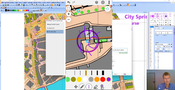
Working with the OCAD Sketch App
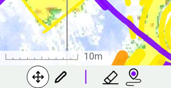
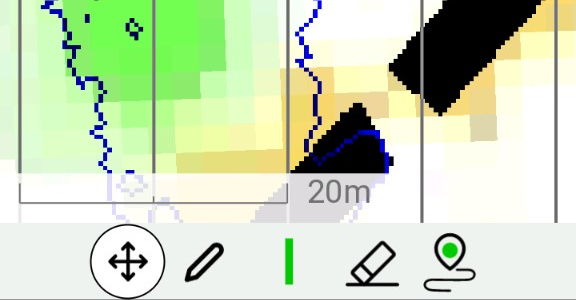
Make use of the scale bar that has been added in the latest update of the app. The scale bar can be turned on or off in the settings.
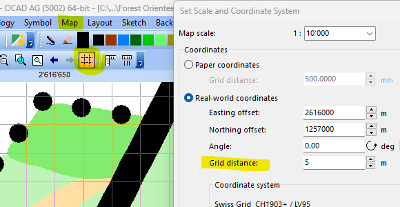
Adjust the distance between the north lines. You can do so in the settings. E.g., set it to 1mm in a project with a 1:10’000. This gives you every 10 meters a line. In a 1:4’000 project, use 2.5mm to get a line every 10 meters.
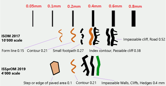
Know the different line widths. It is advantageous to know the line widths and to sketch objects accordingly. E.g., an impassable wall on a sprint map with a line width of 0.4mm and contour lines with a line width of 0.21mm.
In OCAD Desktop, it is also possible to check directly during drawing whether the drawn line or area object corresponds to the minimum dimension of the IOF, as we explain in this blog post.
The OCAD Route Analyzer 2.0 has been released as a beta version.
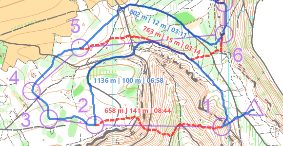
Thanks to the consideration of runnability and relief, the Route Analyzer 2.0 can find the fastest routes between two controls in urban as well as in classic forest terrain.
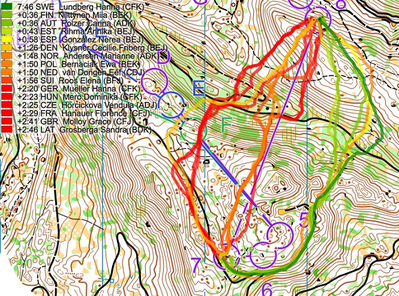
The fastest calculated routes (blue) and alternatives (red).
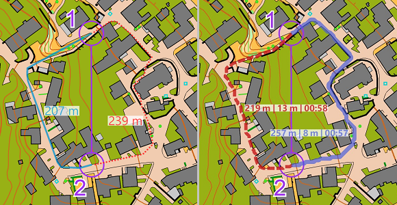
The previous version of the Route Analyzer is limited to 2D sprint maps, because it assumes a constant speed and only distinguishes between passable and impassable map objects. The shortest route is displayed as the result.
Comparison between the old and the new version of the Route Analyzer. The left route option is shorter, but has more meters to climb than the right option.
Consideration of runnability and relief
To find the fastest route, the Route Analyzer takes into account the distance, the relief and the runnability.
Therefore, resistance values are assigned to the individual map symbols. These are based on assumptions and can be changed in the settings. It is well known that the forest is not equally runnable depending on region and season.
The influence of the relief must be divided into two factors: The difference in altitude in the running direction and the slope transverse to the running direction. The latter causes a reduced speed when running along a steep slope.
In order to take the elevation into account, a DEM has to be loaded. For runnability, each OCAD symbol is assigned a resistance value, which can be adjusted manually.
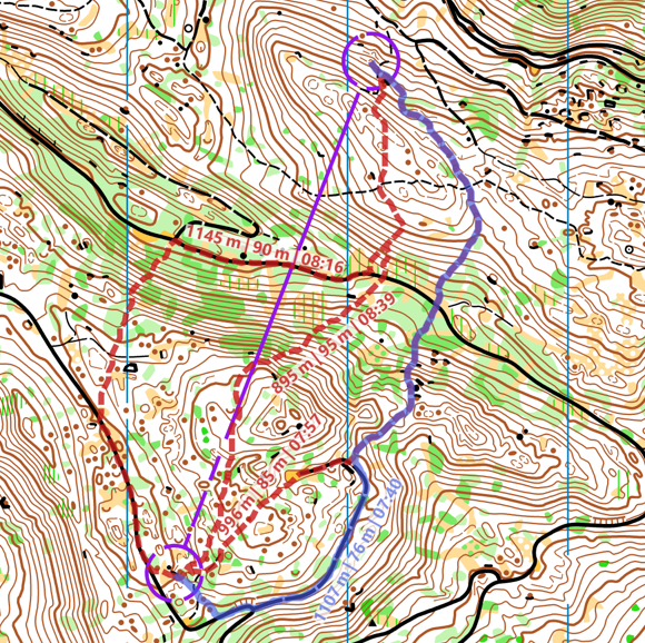
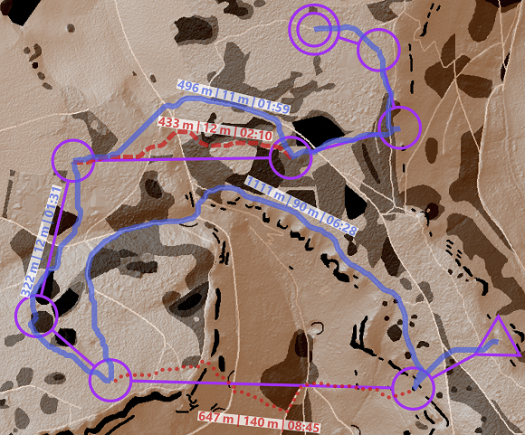
Taking these influencing factors into account, the algorithm calculates the fastest route from one control to the next. Alternative routes can be added with via points, which are mandatory to pass. In OCAD, the distance, climbing and expected running time are displayed for each route.
The fastest calculated routes (blue) and alternatives (red) in the WOC 2023 Women Relay.
Up-to-date map symbols and elevation model required
A prerequisite for correct functioning with the new calculation method is a map with a current set of symbols and a digital elevation model (DEM). When assigning the resistance values, OCAD accesses the map symbols. If their properties (symbol number, color values, line thickness, etc.) are within a range defined by OCAD, an assignment is made. An up-to-date symbol set that complies with the specifications of the International Orienteering Federation is therefore advantageous.
The DEM is normally created by the map maker to calculate e.g. contour lines or a hill shading map. Newly, the DEM can be more easily passed on to the course setters as an optimized and compressed Course Setting DEM (ocdCsDem) due to the greatly reduced file size, or even directly embedded into the map file or course setting file.
Resistance Layer and hill shading map.
Many application possibilities
Thanks to the relative time difference between route variants, the Route Analyzer 2.0 can be used as an aid for planning exciting route choices in all orienteering disciplines. In addition, it can be used to calculate distance, amount of climbing and expected running time along the ideal route of an entire orienteering course at the push of a button. Besides, the Route Analyzer 2.0 can also point out undesirable or dangerous routes, e.g. due to missing restricted areas or unclearly drawn maps.
Whether the displayed route is actually the fastest route depends on individual factors such as personal strengths, in addition to those already mentioned such as region and time of year. With the help of GPS routes, the fastest route can be determined in retrospect or at least guessed. Nevertheless, it is exciting to compare the personally favored routes with the calculated results.
Route comparison by Jan Kocbach (World of O) WOC 2023 Women Relay.
At OCAD, we not only develop and maintain the OCAD software, but we are all active cartographers, course setters, and map controllers. Almost all of us.
OCAD Team from left to right: Hubert, Gian-Reto, Andreas, Rahel, Alistair, Thomas
Gian-Reto Schaad is a very experienced cartographer and member of the Swiss Orienteering Map Commission, who completes every year several smaller and large mapping projects using his Windows tablet. Furthermore, he is responsible for the layout and print preparation of all maps for the Swiss O Week 2023.
Hubert Klauser, also a member of the Swiss Orienteering Map Commission, is doing several maps each year, such as the very demanding Kernwald earlier this year. Developing the OCAD Sketch App and at the same time test it extensively in the field went hand in hand.
Andreas Kyburz has also recently been involved in major mapping project, where he felt in love with the OCAD Sketch App. The former member of the Swiss National Orienteering Team also likes to set challenging courses for training and competitions. The OCAD Route Analyzer helps him with this.
Thomas Gloor concentrated mainly on being map chief and map consultant for the region of Northwestern Switzerland after a long period of activity for both the IOF and the Swiss Map Commission.
Alstair Landels is our new employee at OCAD since June this year. As a former World Cup winner (1994) he knows how to set interesting courses for orienteering races. With Alistair, the OCAD team becomes more international. Born in New Zealand, Alistair lives and works in England.
Rahel Lozano is our accountant and has nothing to do with cartography and orienteering. She makes sure that the orienteering freak show doesn’t get too out of hand by talking about normal life.
We regularly receive requests from orienteering clubs who are planning a course setting or mapping course for their members and need OCAD licenses.
We are happy to provide a free OCAD training license for this purpose. The license can be installed and used by the members on their own devices for the duration of the training course.
Example: – Training license for a 2 week course setting course with 5 participants. – Training license for a 5 week map making course with 20 participants.
Advantages: Unlike the OCAD Trial version, the training license does not contain any restrictions and can also be used by users who have already installed an OCAD Trial version.
How do I get a license? Send an email to info@ocad.com with the following information: – Club name – Which edition you want (OCAD Course Setting, OCAD Starter, OCAD Orienteering) – Course start date – Course end date – Number of expected participants
At most orienteering trainings and competitions it is customary to survey the control locations in the field before the event and occasionally update the map near the controls.
We’ll show you inthis video how to make the best use of OCAD.
Avoid extra work: Use geoservices in advance
There is lot of geodata available, that helps you to get a nice first impression of the terrain, even if it is unknown to you as a course setter.
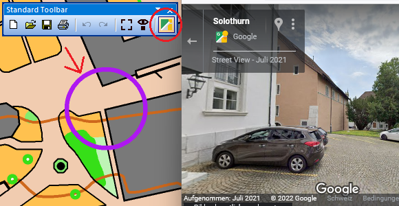
E.g. for spint courses in urban areas, the GeoViewer function in OCAD opens Google Street View (or another GeoViewer Service) at the indicated location. This makes it possible to estimate whether a control can be set or not.
Thanks to WMS/WMTS or Online Map Services, it is possible to load survey data or aerial photographs and check whether new buildings (urban) or clear-cuts (forest) are visible.
The use of all these geo-services is of course dependent on their up-to-dateness and a terrain inspection is nevertheless required. However, a quick check with this tool can save a lot of extra work.
Check control sites with OCAD Sketch App
Now when you go to check the control locations in the terrain, the OCAD Sketch App is highly recommended.
You can download the OCAD Sketch App for free on your mobile device (Android smartphone/tablet or iPhone/iPad) and load your courses on it.
This has two big advantages:
The GPS position gives you additional security in the terrain whether you are at the right control site or not.
You can capture map corrections and notes on your mobile device for yourself or send them directly to the controler, map maker or event adviser.