Symbol Status Manager

The Status Symbol Manager allows you to save and load different status settings of your symbols in the same map.

Example:
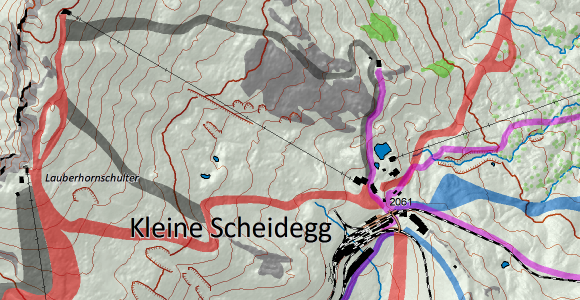
We have a topographic map, which shall be used in summer and winter.

For that, we first create a summer edition of the map.

Now, we save the current Symbol Status of the summer map in the Symbol Status Manager.

Afterwards we change the summer map, e.g. we remove tracks and add ski slopes to get our winter edition.

It’s important to save the newly created winter edition in a new symbol status. Otherwise, we would overwrite the summer edition.

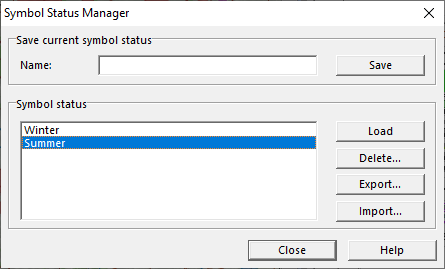
You can now choose between loading the summer or the winter edition of your map. When you change the map, e.g you add a new building, it will be taken over in both summer and winter edition.

See short video on YouTube.
More information on our OCAD Wiki.


Convert Area or Line Objects to Point Objects

You may have symbols on your map, which consist of many different line and/or area objects. Editing and moving around these Symbols can get tedious. In OCAD Mapping Solution, there’s a function to Convert Area and Line Objects to a Point Symbol (Wiki).

A typical example for this function would be the import of a PDF. Vector objects in PDF files are imported as Image Objects (grey objects) and can be converted to Point Symbols (green objects). Learn here, how to Create a Point Symbol out of Vector Data (Video).

Convert Line and Area Objects to Point Objects

Your map becomes more consistent and better structured.

ISSprOM 2019

The latest mapping standard for sprint orienteering maps, called ISSprOM 2019, has been published by the International Orienteering Federation (IOF). The document can be downloaded from the IOF website.

OCAD has implemented the new standard in their symbol sets, which you get with the latest Service Update. The ISSprOM 2019 is valid from 1 January 2020. Until then, the current ISSOM 2007 is still in use.

In order to keep track of all the different symbol sets that have been released lately, we created the Wiki page Symbol Set Overview. There you’ll also learn how to convert your maps to the new standards.

Comparison ISSOM 2007 and SSprOM 2019

Major changes:

  • Impassable vegetation (410) is forbidden to cross. Previous ISSOM 2007 Impassable vegetation symbol (421) using green 100% and black 50% has been removed.
  • Paved area with little (Brown 30%) and heavy traffic (Brown 50%).
  • New symbol for paved area in multilevel structures.
  • New symbols for passable walls, fountains and trees.

Updated ISOM 2017-2

The updated International Specification for Orienteering Maps (ISOM 2017-2) has been published by the IOF Map Commission recently.

OCAD has implemented a new function Update Symbol Set to update maps drawn according to ISOM 2017 to the new ISOM 2017-2 standard. There will be approximately 15 changes to your symbol set.

ISOM 2017 Comparison
Dialog box after updating a 1:10’000 map from ISOM 2017 to ISOM 2017-2

The changes have also been adopted to the OCAD symbol sets “Orienteering Map ISOM 2017 10’000” and “Orienteering Map ISOM 2017 15’000”. So, if you start a new map, you work automatically with the latest ISOM 2017-2 version.

Create Objects with Pairs of Coordinates

In OCAD, you can create objects with pair of coordinates. Copy coordinates e.g. from Google Maps to clipboard. When you press Paste in the OCAD window (Ctrl + V or in the Menu Object> Paste), a dialogue window appears.

Now you have three options:
You can move the view to this coordinates, create point objects at the coordinates or create line or area objects (only available if more than one pair of coordinates exists).

To use this function properly, a coordinate system has to be defined and the pasted coordinates need to fit to this coordinate system.

Link to HowTo-Video
More information on our Wiki

Supported formats so far:
– Google: 47.4563036,7.6405326
– Google: -24.8512749,-59.8029067
– OpenStreetMap: 47.45295/7.64673
– OpenStreetMap: -37.762/-62.183
– OpenStreetMap: 46.3103041, 4.8142705
– geo.admin.ch: 615’582.01, 256’284.55
– geo.admin.ch: 47.45648, 7.64039
– geo.admin.ch: 47°27′23.313″N 7°38′25.401″E