We hope you all had a good start to the new year and wish you all the best for 2024.
In this blog post, we take a look at what has been added to OCAD over the last year in terms of functionality and learning aids.
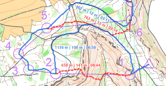
OCAD Route Analyzer 2.0
The Route Analyzer 2.0 now also takes into account the relief and the runnability. With it, the fastest routes can be calculated in urban as well as in classic forest terrain.
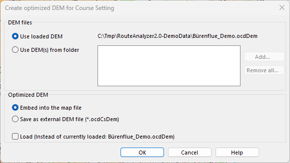
Optimized DEM for Course Setting Available
To ensures that the climbing and slope gradient are included in the route calculation of Route Analyzer 2.0, an optimized elevation model can be embedded directly into the map or course setting file. This significantly reduces the file size of the DEM and makes it easier to exchange.
OCAD Sketch App Improvements
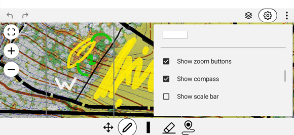
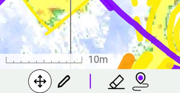
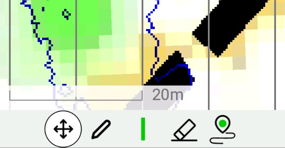
Improvements have also been made to the OCAD Sketch App: – A scale bar to improve the distance feeling within the app – Additional colors for sketching – Improved position display of the internal GPS on Android devices
On mobile devices, you can zoom in and out at will. Zooming in is appreciated by the map makers as it allows more precise drawing and sketching and more accurate display of the background map.
However, by zooming in and out, map makers are not working at a fixed scale and so the sense of distance within the map is lost. This was easier when mapping with pen and paper where the scale was fixed.
A few things can be done to improve the feeling for the scale on a mobile device:
Working with the OCAD Sketch App
Make use of the scale bar that has been added in the latest update of the app. The scale bar can be turned on or off in the settings.
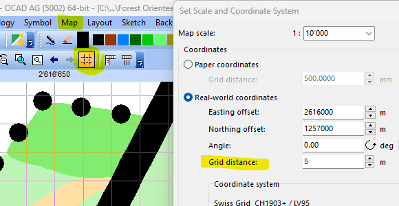
Adjust the distance between the north lines. You can do so in the settings. E.g., set it to 1mm in a project with a 1:10’000. This gives you every 10 meters a line. In a 1:4’000 project, use 2.5mm to get a line every 10 meters.
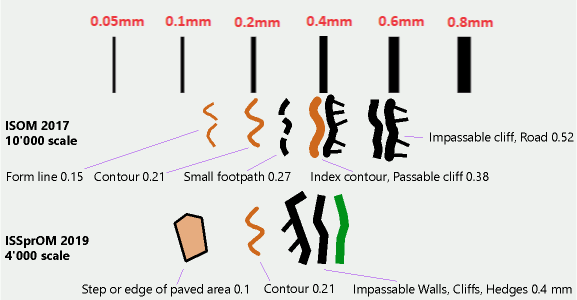
Know the different line widths. It is advantageous to know the line widths and to sketch objects accordingly. E.g., an impassable wall on a sprint map with a line width of 0.4mm and contour lines with a line width of 0.21mm.
In OCAD Desktop, it is also possible to check directly during drawing whether the drawn line or area object corresponds to the minimum dimension of the IOF, as we explain in this blog post.
In OCAD you can draw sketches directly using the Sketch toolbar or import them from the OCAD Sketch App via the OCAD Sketch App Data Exchange tool.
What is the best way to manage these sketches? How do I make sure that I draw all sketches?
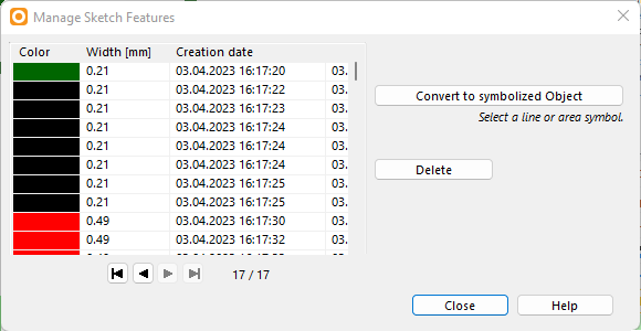
Manage Sketch Features All sketches are listed in the menu Sketch > Manage Sketch Features. When a sketch is selected in the list, the OCAD drawing area is centered on it.
Manage sketch features dialog.
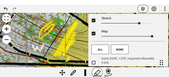
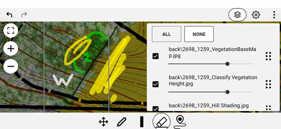
Show Sketches Under Menu Sketch > Options there are different display options that make sense depending on the situation. We recommend testing different transparency and opacity settings, e.g. if sketch features should be behind map objects or not.
Sketch options dialog.
Opacity: An sketch feature opacity of 100% will cover the map objects behind it.
Transparent: If the rendering of the sketch features is slow, the transparency should be turned off.
Opacity 70%, transparency on, display sketch layer behind map unchecked.
Display sketch layer behind map: We recommend to activate this option during the final drawing. For mapping in the terrain with a Windows tablet and OCAD Desktop, it’s better to have the sketches before the map. In the OCAD Sketch App, the Sketch layer is always before the map.
Hide sketch features: All sketches can be hidden in the toolbar or under menu Sketch > Hide. Advanced users can also use a Shortcut.
Delete Sketches The following options are available for deleting sketches.
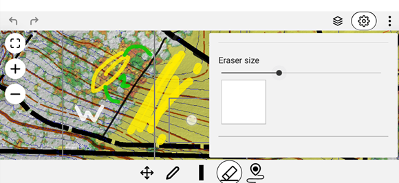
Eraser The eraser in the sketch toolbar can be used to erase sketch features completely or partially. In contrast to custom OCAD map objects no preliminary feature selection is needed for this. Depending on the zoom level, sketch features can be erased with varying degrees of coarseness. Zoom out to quickly delete features over a large area.
Delete All Sketch Features The function in the menu Sketch > Delete All Sketch Features deletes all sketch features.
Manage sketches Sketches can be deleted individually in the menu Sketch > Manage Sketch Features.
Different ways to delete sketches.
Visual Inspection At the end of the final map work, the question arises: Have I worked through all my sketches? In case the sketches were deleted or erased during the final map work, you can check the list under Sketch > Manage Sketch Features.
If the sketches were not deleted during the final map work, a visual check is necessary. To make the sketches clearly visible, the map and background maps can be displayed transparently or not at all.
Switch to Draft mode and use the slider in the View toolbar to set the opacity of the map (M) and background map (B) to the far left.
Alternatively, you can hide the map and the background map (menu Map > Hide; menu Background Map > Hide All).