Tag Archives: New Map Wizard

Script Error: New component required for correct display

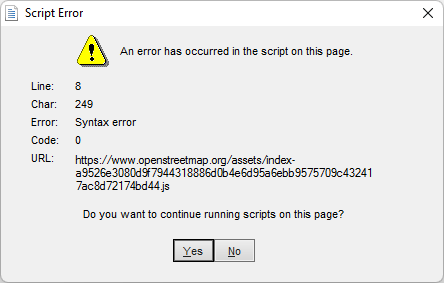
In some cases, Open Street Map integration with OCAD no longer works properly and you receive a Script Error message like the following:

How to solve this issue ?

Functions that may be affected by this error message includes New Map Wizard, Rotate Map to Magnetic North, Magnetic Declination and Online Map Services.

This bug will not be not fixed in OCAD 12.

How did this error happen?

Open Street Map no longer supports Internet Explorer, which was previously used in OCAD to display web content. That’s why OCAD uses now Microsoft Edge WebView2. Microsoft Edge WebView2 is already installed on computers running Windows 11, but not on older versions of Windows. Therefore, the Microsoft Edge WebView2 must be installed manually on these devices.

One-Click Map on a new level

For many years, a vision of OCAD has been to create a usable orienteering map with just one click.

With the latest OCAD Update we have come a step closer to our vision.

Thanks to freely accessible geodata, excellent maps for Switzerland and Finland can be created with the New Map Wizard. The trend towards freely available geodata can also be observed in other countries and we hope to be able to include these countries in the function as well in near future.

Video examples:

More information is available in the OCAD Wiki. The whole auto-generated Jukola 2020 Map Rovaniemi can be downloaded here.

Note: The geodata import for Finland and Switzerland is still a Beta version. Feedback is welcome.

Extract of auto-generated map from Jukola 2020 in Rovaniemi.
Extract from auto-generated sprint map of Baar.

Open Street Map to ISOM 2017

There is a new features available in the current version of OCAD. You can create a new orienteering map based on open street map data.

Click on File -> New Map Wizard. A dialog appears. Choose ISOM 2017, set the scale and click on the button with the three dots to choose a filename.Click Next.

Enter a name of a town in the search field and click on Go. Move the map to the center to choose the right area. Change the coordinate system in the bottom.Click on Next.

Change the .crt file to ‘OSM to ISOM 2017.crt’. 

Wait a few minutes and you will get shown the imported OpenStreetMap data with ISOM 2017 symbols. Perhaps you have to delete some huge areas that cover the entire map.