The newest OCAD 12 Orienteering Service Update 12.1.2 contains a new function to import geodata in Shape file format. Up to now this function was only available OCAD Professional and Mapping Solution.
Geodata are more and more freely accessible from government as Open Data. So use this geodata and import them in OCAD before starting drawing.
Example of geodata import (streets) from swisstopo :
File -> Import and choose the shp file. The Import Shape File appears.

After the import you have to assign the imported objects to existing symbols. So import also the classification from Shape file.
Chose Use layer information from field option and click on the View table button.
In the View Table dialog you can see all database fields with the values.

The classification (2_Klass, 3_Klass, 4_Klass,….) is in the OBJECTVAL field. Close this dialog and choose the OBJECTVAL field.
Click OK to import the data.
All imported objects are unsymbolized. Select one line object. The layer information 4_Klass for this object is visible on the left side of the status bar.

Assign these objects to symbols using the Convert Imported Layers to Symbols in the Map menu.
Click the Add all button to add all layers in the table. On the right side choose the corresponding symbols.
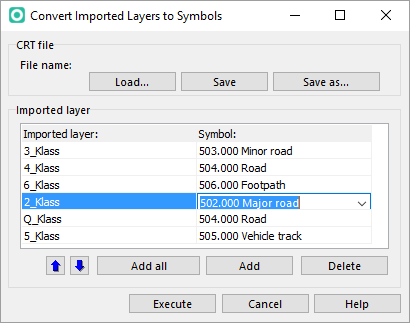
Click Execute to symbolize the objects.

Pingback: Shape File Import now in OCAD 12 Orienteering