Create WGS84 Grid
Jump to navigation
Jump to search
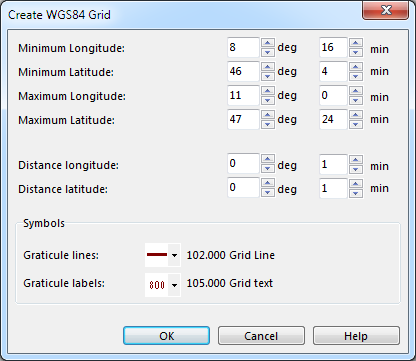
This command is activated when you have set the Coordinate System in the Map menu and can be found in the Map menu as well. The Create WGS84 Grid dialog appears.
You have to enter several values now:
- Minimum Longitude: Enter the minimum longitude (where the first grid line is to be drawn) in degrees and minutes. A degree-value in the east of the zero meridian has to be written with positiv sign, a degree-value in the west with a negative sign.
- Minimum Latitude: Enter the minimum latitude (where the first grid line is to be drawn) in degrees and minutes. A degree-value in the north of the equator has to be written with positiv sign, a degree-value in the south with a negative sign.
- Maximum Longitude: Enter the maximum longitude (where the last grid line is to be drawn) in degrees and minutes. A degree-value in the east of the zero meridian has to be written with positiv sign, a degree-value in the west with a negative sign.
- Maximum Latitude: Enter the maximum latitude (where the last grid line is to be drawn) in degrees and minutes. A degree-value in the north of the equator has to be written with positiv sign, a degree-value in the south with a negative sign.
- Distance Longitude: Enter the distance between the longitude graticule lines in degrees and minutes.
- Distance Latitude: Enter the distance between the latitude graticule lines in degrees and minutes.
- Symbols:
- Graticule lines: Select a line symbol for graticule lines (map grid).
- Graticule labels: Select a text symbol for graticule labels.
Click the OK button when finished.
![]() - Create Graticule Name Index is the corresponding function to create a graticule name index.
- Create Graticule Name Index is the corresponding function to create a graticule name index.
- - Read more about the WGS84 Grid in the Wikipedia Article.
Back to the Map page.
