Tag Archives: Orienteering Map Specification

Updating Orienteering Maps in OCAD

Not every map project covers unmapped terrain. Actually, it is quite likely that an older orienteering map of the same area already exists.

As our environment is constantly changing, sooner or later orienteering maps have to be updated. But how is this best done?

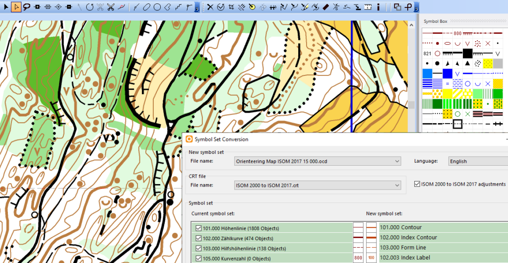
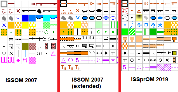
We have created a Wiki page about Updating Orienteering Maps in OCAD. It contains a possible workflow, as well as numerous tips and suitable functions.

Have fun reading it.

Updating_Orienteering_Maps

Update your Old Maps

Orienteering maps should been drawn according to the International Specification for Orienteering Maps (ISOM). This ensures that different types of terrain around the world are mapped with the same symbols that every orienteer understands.

These specifications are updated from time to time. For example, the specifications for Forest Maps (ISOM 2017) and Sprint Maps (ISSprOM 2019) have recently been revised. Orienteering maps, which were still drawn with symbols of an old specification, can be easily updated to the current specifications in OCAD.

Sometimes it’s tricky to find out which symbol set is the current one or with which symbol set a map was drawn. The wiki page Symbol Set Overview was created for this purpose.

A demonstration how to update a Sprint Map from ISSOM 2007 to ISSprOM 2019 can be seen here.

Map your Home

Have you always wanted to get to know your home better? Do you have to entertain the kids somehow? Or maybe you just have some more time and want to make your first map?

Then let’s start and map your home with our new symbol set.

The following three steps will give you a good start.

#1: If you are not yet working with OCAD, download and install OCAD Trial. Choose the Orienteering Edition.

#2: Download the MapYourHome_SymbolSet.ocd from our website or directly here.

#3: Watch this short video on YouTube, which helps you to set up a map.

Fantasy Home Sample Map

If you want to learn more about OCAD and how to use it, please go to the OCAD Quick Start Wiki page. For more advanced users, we can recommend the Tutorial Drawing Orienteering Maps in OCAD.

Symbol Set for School Orienteering Maps

Until recently, there were many symbol sets for drawing school orienteering maps. Therefore, the IOF Map Commission has been commissioned to produce a simple set of symbols for school maps for scale 1:1000 to 1:2500. The basis for the symbol set for school orienteering maps is the ISSprOM 2019. All symbols of ISSprOM 2019 have been enlarged to 125% and 6 additional symbols have been added (see pictures below).

If you like to use this symbol set in OCAD:
– File > New
– Map type: Orienteering map
– Load symbol set from: Symbol Set for School Orienteering Maps 2019.ocd

The default Map scale is 1:1’000. If you like to draw your map in a different scale, just enter the desired scale. Do not Scale symbols.

Playground equipment
Bench
Table
Pole
Lamppost
Hydrant

Check Legibility of Orienteering Maps

Nowadays, when mapping with high resolution and accurate base maps, the temptation is great to draw too many and too small objects. This may result in a poorly readable map.

The function Check Legibility veryfies minimum distances between objects, minimum length of line objects or minimum size of area objects according to ISOM 2017.

This will help map makers to find the right degree of generalisation and make the maps better readable. Furthremore, Event Advisers and Map Consultants have a tool to check the maps.

CheckLegibility

Short video about the function on YouTube.
More information on our OCAD Wiki.