Tag Archives: Mobile Mapping

Review of OCAD Development in 2021

Let’s take a look back at the three most important developments of the past year. Did you get them all?
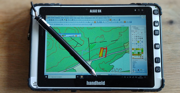
#01: Sketch Layer

The Sketch Layer and it’s tools are designed for orienteering map field work with a tablet computer and a pen. The main approach is to make field work drawing as ergonomic as possible.

Learn more about it in our Video on YouTube and in the OCAD Wiki and and give it a try!

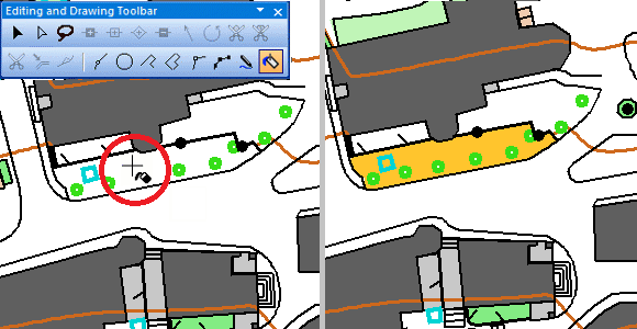
#02: Fill Bounded Area mode

Thanks to the Fill Bounded Area mode you can draw your map even more efficiently. This function fills empty areas that are bounded by various objects from line or area symbols.

#03: Improved Live Preview

The Live Preview of objects makes their dimension visible already during drawing. Live preview is no longer limited to line objects, but is now also available for point objects.

In addition, a so-called Legibility Halo can be displayed for point objects. The distance of this legibility halo is based on the IOF specifications for orienteering maps and supports the cartographer to draw objects with enough distance to each other.

These were the biggest milestones last year, but stay tuned: We have great innovations in the pipeline this year as well!

Freehand Mode for Tablets

The OCAD Sketch Layer is designed for sketching objects on a tablet.

Of course, objects can also be drawn directly with a drawing mode such as Curve, Straigth line or Freehand mode.

However, the Freehand mode was not very intuitive until now. Fortunately this has improved since the last OCAD update.

The Freehand mode for tablets now feels as intuitive and natural as drawing with the Sketch Layer, as you can see in this video.

For that, you need to select the option  Freehand mode: Adapted for tablet with pen in the OCAD preferences.

OCAD Sketch Layer

With the latest update we launched the OCAD Sketch Layer as a Beta version.

The new Sketch Layer and it’s tools are designed for orienteering map field work with a tablet computer and a pen.

OCAD Sketch Layer

Mapping with a tablet in the terrain has some compelling advantages like real-time GPS positioning and the possibility to switch between different background maps. However, the drawing and editing tools were not yet designed for use with a tablet and pen.

This was the trigger for this latest development: The OCAD Sketch Layer makes drawing on the tablet very ergonomic. Even more: Numerous colors and different line widths are available and with the eraser tool you can very easily delete parts of the sketch without having to select the features before.

Learn more about it in our Video on YouTube and in the OCAD Wiki

… and give it a try!
The Sketch Layer can be used with the latest Update of the OCAD editions Mapping Solution, Orienteering and Starter and in our free Trial versions of these editions.

We look forward to your feedback and suggestions!

Note: The tools and functions around the OCAD Sketch Layer are a Beta version. We recommend to make regular backups.