Tag Archives: DEM Wizard

Create Digital Elevation Models in OCAD

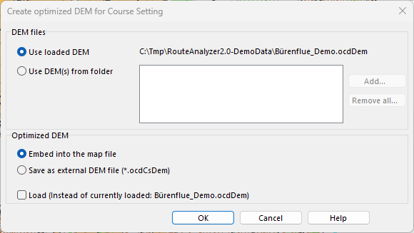
To use the OCAD Route Analyzer 2.0, course setters need a current map as well as a Digital Elevation Model (DEM).

This is loaded into the map or course setting file and ensures that the climbing and slope gradient are included in the route calculation. The DEM is typically created by the cartographer and has traditionally required a lot of memory.

The DEM can now be optimized and compressed without loss of quality for route calculation. This significantly reduces the file size of the DEM and makes it easier to share. The optimized elevation model can also be embedded directly into the map or course setting file, as is already possible with layout images.

How to create an optimized DEM (Video)

More information (Wiki)

Create Cleaner Contours

One of the strengths of OCAD is the generation of smoothed contour lines.

With the latest Service Update, a combined method of TPI and 3D smoothing is used for the calculation, which leads to improved results. The file size also shrinks, because at the same time irrelevant contour vertices are removed and the contours are converted into Bézier curves.

In our example, the not smoothed contours appear brown. The smoothed contours according to the new method (blue) are cleaner and show the terrain more precisely than according to the old smoothing method (green).

How contour lines can be generated is described in detail in our Wiki.

Multi-directional Hillshading

A hillshade is a shaded relief picture of the surface. Important for a hillshade is the position of the imaginary light source, which is taken into account for shading the image.

Normally, the direction of the light source is 315° (north-west). Since the Service Update 20.5.3, it’s also possible to choose the option Multi-directional. It is a composite image made up of four images in which the light source comes from different directions. Like this, the terrain is more realistically represented, and overexposed and nonilluminated areas of the map are more balanced.

In OCAD, Hill Shading can be created from the DEM menu or from the DEM Import Wizard.

Vectorize automatically cliff features

A new function has been added to the latest OCAD 2018 Service Update: Vectorize automatically cliff features.

With OCAD, you can now automatically convert cliff features from the Slope Gradient calculation into vector symbols.

Please find more information in our Wiki.

To use this function, you need the latest OCAD 2018 Service Update, which can be downloaded from the Help -> OCAD Service Update function in the OCAD program.