The OCAD Sketch App is officially released!
We would like to thank you for the many feedbacks and improvement requests. These motivate us to further develop the Sketch App and make it even better.
All information about the OCAD Sketch App is available at www.ocad.com/app.
What’s new with the release?
– The app is now available in Google Play Store and Apple App Store. Search for OCAD Sketch.
– When uploading data from OCAD Desktop to OCAD Cloud Transfer, a link will be generated in addition to a QR Code. This link can easily be sent to the mobile device, e.g. via email, SMS or WhatApp. On your mobile device, just click on the link to download the data into OCAD Sketch App.
– The OCAD Sketch App Data Exchange tool is now available in different languages.
– Thanks to some bug fixes, the app runs more stable.
Have you already installed the app?
Then update the app in Google Play Store or Apple App Store. All your previous projects will still be available in the official version.
Haven’t you installed the app yet?
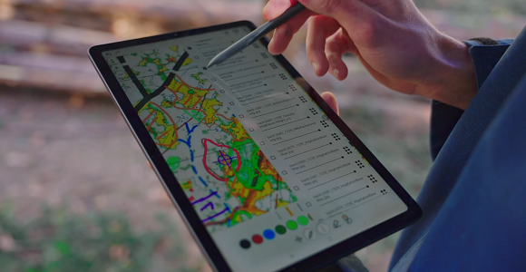
Then get going! The OCAD Sketch App provides a great mapping experience in the field- both for new mapping and for revisions, feedback from course planners or map reviewers.
What’s next after the installation of the app?
To work with the app, you must first load a map project onto the app. You can do so in several ways:
– Learn how to transfer a project from OCAD Desktop to the app in our OCAD Wiki or in this video. Please install the latest OCAD Update first. Request a free OCAD Trial if you have no OCAD Subscription license.
– Request a link or a QR code for a project from another person, e.g. a club member.
– You can also download our Demo Project.
Still looking for a suitable tablet?
We have put together a few recommendations on our OCAD Wiki page.
The OCAD Sketch app is more advanced on one particular feature than OCAD desktop. It allows drawing other objects on the screen while the GPS track is drawing its own line. In desktop OCAD, it is impossible. If you start the GPS line, you can’t add other symbols while GPS is working. You would need to stop it, select other symbol, draw it and then select again the GPS line that you stopped, and restart the GPS line. It takes significant additional time and lost of productivity in the field.
I would like to request this feature to be implementing in OCAD desktop software.
Thank you.
Grüezi Dmitri
Thanks for your comment and feature request. We will add it to our wish list.
Best Regards,
Andreas
In order to draw Swiss Topo Style Cliffs, it is necessary to draw a line with a variable width that is similar to Calligraphy. Does the Sketch App offer this capability for a stylus and a tablet ?
Hi
You can choose between different line widths, but the OCAD Sketch App does not offer the possibility to draw a line with a variable width.