We are pleased to announce the release of OCAD 12 Beta Test Version. OCAD 12 offers many new features and numerous improvements, which facilitate map-making and thus your work.
Smart Editing Tools
Several new smart editing tools have been added, including:
- Move object segments
- Move building corners keeping rectangular angles
- Remove multiple vertices with a brushing action
- Show draft line when moving/stretching/rotating an object
- Move single line or area vertex with arrow keys
Generalization Tools
Several new generalization tools either for rectangular features (e.g. buildings) and for line features (e.g. contour lines) have been added.
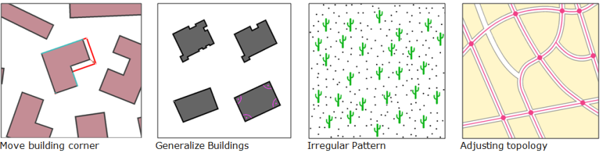
Irregular Pattern
Representing area symbols (e.g. forest or scree) with irregular patterns. Structure elements can be cut or displayed completely at the border line.
Topology
Several new tools for adjusting topology have been added:
- Remove duplicate vertices
- Cut lines at intersections and/or insert point objects
Step-by-Step Wizard for DEM
LiDAR and DEM data are becoming more important for creating topographic maps. A step-by-step wizard helps you to analyze them and create hill shadings, contour lines, cliffs and vegetation height. Moreover you can lay profiles to analyze intermediate LiDAR impulses.

Docking Panels
The symbol box and other tool boxes can be detached and placed anywhere.
Time Stamp for Objects
Objects get a time stamp when created or edited which can be looked up.
64-bit Version
OCAD 12 will also be available in a 64-bit version for better handling of background files and any other large files.
Multiple Representation
Multiple representation enables the creation and display of cartographic objects at different locations (e.g. text label displacements) and different map styles.
Automation with XML Scripts
Mapping processes can be automated with easily created XML scripts. It is also possible to use XML scripts to create thematic maps.
The OCAD 12 Beta test version is available free of charge to all current users of OCAD 11 Orienteering Standard or Professional. OCAD 11 must be installed and activated on the same computer.
Download link: OCAD 12 Beta Test
We wish you a lot of fun exploring OCAD 12 Beta and look forward to your comments.
Those who buy OCAD 11 Orienteering Standard or Professional during the Beta testing stage receive an OCAD 12 update for the same edition for free upon its official release.
OCAD 12 Crashes on loading Lidar file.
Hi,
I thought I would get a sample Lidar file and see how it loads into OCAD. But it crashes OCAD 11 and OCAD 12. Could you investigate please.
The Lidar file is at:
https://drive.google.com/file/d/0B9MWJDJxV2tEdlZsOVNwczdubVU/view?usp=sharing
What I did with it is shown in this video:
https://youtu.be/Tb5hxIbjRJo
Regards
Peter Effeney
Hi Peter
Thanks for your comment and the test data.
In the LAS Setting check the classification option ‘Other’ for the DTM.
Then it works!
Gian-Reto Schaad, OCAD Team
Using OCAD 12 on the test area (about 200×200 m with very dense lidar!) I get one obvious problem:
About 2000-2500 dot knolls on the SE corner of the map, an area which looks like an obvious lake at around 887 m above sea level?
Using LAStools to classify the unclassified raw point clouds leaves a much cleaner data set…
It does seem like some sort of open highland/moor, somewhat hilly and with a few areas of green stripes, i.e. chest-high vegetation, but otherwise completely open. The strange part here is that a huge percentage of the points have multiple returns, which would seem to indicate multiple points with very small vertical spacing.
Is this data set a result of dense photo matching, i.e. digital processing of high-res stereo photo pairs instead of the more common lidar scans?