There are different ways to display an OCAD map on smartphones. Of course you have already been able to export the map as pdf or jpg and display these files on the smartphone – but the georeferencing has been lost and it was not possible to navigate with these maps. Another option was to export the OCAD map as kmz file and to open this map in Google Earth.
We improved the georeferenced tiff export in the OCAD 11.3.10 Service Update. So the exported raster map is now compatible with mobile apps like Avenza PDF Maps or ape@map .
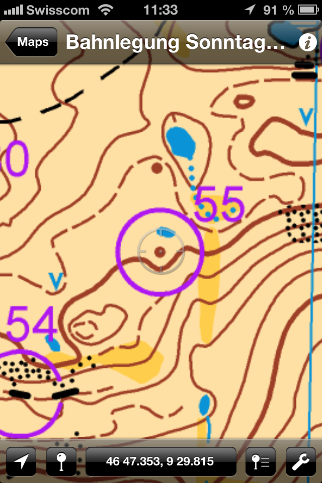
This post shows you how to upload an OCAD map to the smartphone app PDF Maps. This app is free and available for iOS and Android (beta version).
– Please check if your map is georeferenced and the coordinate system is set (Map menu -> Set Scale and Coordinate System).
– Export the map as tiff file and activate the option ‘Create World file’. We recommend a resolution of 300 dpi.
– The app PDF Maps allows you to import the tiff file from iTunes and Dropbox. So copy your tiff file to Dropbox.
– Start the PDF Maps app and press the + icon to import the tiff file from Dropbox. The app processes the map during the import.
– Choose the uploaded map and it will be displayed. The GPS cursor shows the current position on the map.
Thanks to Flemming for the idea!
Link PDF Maps
Hmmm… PDF Map is not recognizing my exported TIF file, as a supported file type, when I try to import it from Dropbox?
PDF Maps is recognizing the exported georeferenced TIFF file if color depth: RGB (24 Bits) is chosen in OCAD TIFF export settings.
Using the tiff rgb option for ocad export and loading it on the ipad by itunes seems to work fine, using the 256colour option allows to view the tif file on the ipad but it is not georeferenced. so ist it really the colour depth, which is the problem or does ocad transform the world tiff file in the rgb option directly into a different file type like geotiff?
Ah Ha… the TIF file needs to be 256 (8bit) colour in order for PDF Map to read it.
Also the TIFF expoer did not want to impoer into the PDF Map ANdroid App.
This is the response from the developer…
“The PDF Maps app does not support the loading of tiff with tfw files.
All maps must be geotiffs, geospatial PDFs or GeoPDFs.
You should go back to your map in OCAD and export as one of these formats or use something like Photoshop (with Geographic Imager) or Global Mapper to convert your current tiff/tfw pair.”
Use http://www.mediafire.com/download/a3hv2q9bchez8u8/geotiffexaminer.exe to create a geotiff from tiff with tfw-file.
Nice little software that I have used for many years in my professional work.
Does any one get it working with a tiff and tfw-files in PDF maps? Is it possible to make a geotiff-file export from ocad? or geoPDF?
Geotiff file export from OCAD:
In export dialog choose the ‘Create World file’ to export a geotiff file. This option is only available if the map is georeferenced.
I am able to see the OCAD Internet Map on my iPad or iPhone. The coordinates under cursor are real coordinates. The OCAD is able to Jump to a certain point with function JupToPointOfInterest.
🙂
One small step for OCAD Team, one giant leap for mankind. 🙂 And we will have an Cartographic tool wit no competition.
The main issue that was not mentioned here, is that you need to define your coordinate system and scale in OCAD (under map> Set scale and coordinate system) before doing any exports attempts! Then, export using 24bits, save it in DropBox and then download to Avanza Maps. and that is it!
Apparently, i learned this issue when i was trying to export to KML from OCAD!
I got a geo-referenced map with courses marked onto my android phone but i had to set the colour RGB (24 Bits). Briliant!
It is far simpler to use Custom Maps along with a KMZ Google Earth raster export!
No need to mess around with various TIFF options, or how to combine world georef info with the image, instead the KMZ file will contan everything Custom Maps needs to be able to show it with a moving cursor at the current location.
The only limitation I’ve found is that you cannot use tiling to increase the maximum image size, instead you need to fit everything on a single image with max dimensions determined by the free memory in your Android phone.
I’ve tried all the permutations from the comments and still get “Map not referenced” after importing it into Avenza PDF maps.
I’ve tried 8 and 24 bit and updating the tif file with geotiffexaminer.
Are there any more things I can try?